OS Grid Ref: NH 37774 40490 (access tunnel portal)
Date opened: 1962
Date closed : Operational
The Strathfarrar scheme was one of the last constructed by the Hydro (started
1958, finished 1963), and it shows. A lot of advanced (for the time) and
experimental thinking went into this scheme. The power stations are undergound,
tunneling and construction techniques has reached an advanced stage, having
been honed on earlier schemes, Britains largest arch dam was constructed
for the main reservoir, and Culligran got Britains first (only?) Deriaz
turbine installation. The whole scheme was designed from the outset to
be entirely remote-controlled, with no permanent station staff.
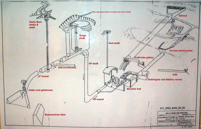
Culligran is a medium-head (180ft) development of the 'traditional' kind
(dam, low-pressure tunnel, surge shaft, high-pressure shaft/tunnel, power
station, short tailrace). Storage is provided at Loch Beannachran, which
has been enlarged (but not raised) by the fairly modest structure of Beannachran
Dam, situated in a gorge downstream of the original outlet of the loch.
Loch Beannachran receives the discharge from Deanie power station, which
is in turn supplied from the main storage reservoir of the scheme at Loch
Monar.
Water is taken from an intake structure adjacent to Beannachran dam into
the main Culligran tunnel, 17,000ft long, to the surge chamber, which is
of the differential type, with seperate main and riser shafts. From there
the water falls down a vertical high-pressure shaft, from the base of the
shaft a short length of high-pressure tunnel leads to Culligran power station,
which is constructed underground. After passing through the turbines at
Culligran, a short tailrace tunnel discharges the water into the river
Farrar. The water from Beannachran is supplemented by one side-stream intake,
on the Neaty Burn. A second side-stream intake was proposed to take additional
water into the surge shaft, andis in fact drawn on the plans for the scheme,
but it was never constructed.
There are 50 images of Culligran in the Records, and 11 webpages. They may all be accessed via the general arrangement drawing
at the bottom of this page, which is a clickable image map. Each area selected
will open in a new window. Drilldown to high-resolution imagery IS available
online for this site.
A short video sequence touring the machine hall exists but is not yet online.
NEW Nov. 2005: On the occasion of my last visit to Culligran, the station
was being extensively refurbished. Some photographs of normally-inaccessible
areas were taken and can be seen on my Culligran Refurbishment page. The rest of the Culligran pages have been extensively updated with new
& improved imagery.
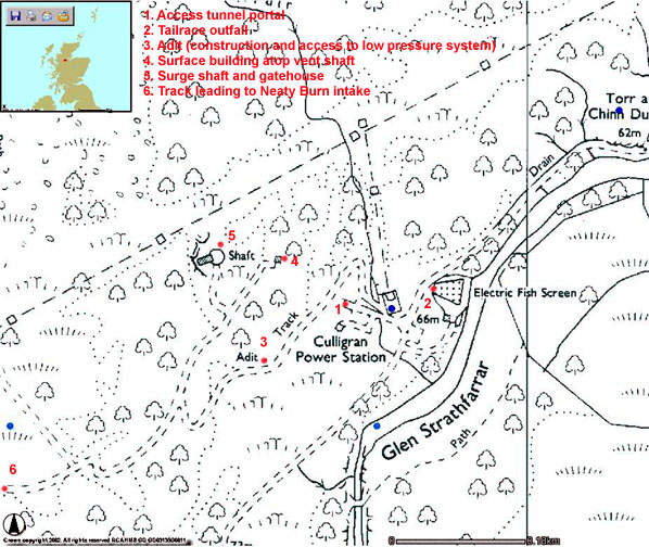
Illustration: Culligran Area Map
Illustration by: Canmap, additional legend Mike Ross
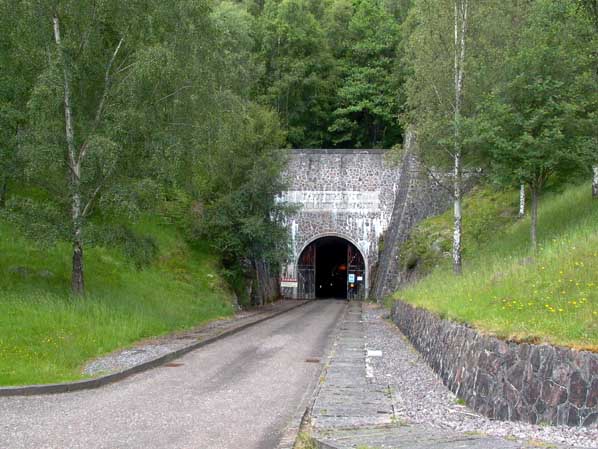
Photo: Culligran access tunnel portal
Photo by: Mike Ross
The drawing below is an imagemap - click on the area you wish to explore (most of the red text is clickable)
 .
.